Data
Chinese Satellite Hyperspectral Data: Supporting for Hymi-X Technology
Compared to other currently operational satellite hyperspectral data worldwide, China's hyperspectral data offers the following advantages:
Larger number of hyperspectral Satellites
As of now, China has successfully launched and operates four hyperspectral remote sensing satellites in orbit, significantly surpassing other countries in terms of quantity.This provides robust support for high-frequency and wide-coverage ground observation, greatly enhancing the comprehensive observation capabilities and global applications of hyperspectral remote sensing.
Wider imaging width and spectral range
Wider image width
China's hyperspectral satellites achieve an imaging swath width of 60 km, significantly exceeding the 30 km swath width of other hyperspectral satellites, such as Germany's EnMAP.This provides a substantial advantage for regional and large-scale observations, greatly improving observation efficiency.
 |  |  |  |  |  |
| ZY1E | ZY1F | GF5B | GF5A | EnMAP | EnMAP |
| Swath Width Comparison of Hyperspectral Satellites in Orbit | |||||
Wider spectral range
China's hyperspectral satellites cover a spectral range of 0.4–2.5 μm, encompassing the visible, near-infrared, and shortwave infrared bands.This broad spectral coverage enhances the satellites' comprehensive capabilities in element and
mineral identification, as well as land cover classification.
Outstanding technical index of data
Much number of spectral bands
Providing 330 spectral bands, significantly exceeding standard multispectral satellites (typically 6–12 bands) and many international counterparts, such as Germany's EnMAP with 242 bands,China's hyperspectral satellites can capture subtle spectral features of ground objects. This makes them highly suitable for detailed classification and compositional analysis.
Much better sensitivity
The high sensitivity with an SNR of 600 enables the satellite to detect subtle spectral signal variations, making it well-suited for detecting low-reflectance targets such as rare minerals.
Much higher radiometric resolution
The radiometric resolution with an SNR of 600 enables the satellite to maintain high detection accuracy even for low-reflectance targets or under complex background conditions, ensuring the reliability of data quality.
Much higher spectral resolution
With a spectral resolution of 0.45 nm, the satellite can distinguish extremely similar spectral features, making it ideal for fine-grained identification of ground objects.
Much higher spatial resolution
With a spatial resolution of 30 meters per pixel, China’s hyperspectral satellites are at the forefront of the field. In mineralization information acquisition, the results are highly consistent with those fromthe 4-meter spatial resolution
hyperspectral data of Nevada Airborne Systems (USA). This demonstrates that China's hyperspectral satellite data fully meets practical demands in the mining sector, effectivelyrevealing mineralization information and providing critical
support for resource exploration.
| China hyperspectral aerospace data spatial resolution of 30 meters |  |
| US Nevada hyperspectral aviation data spatial resolution of 4 meters | 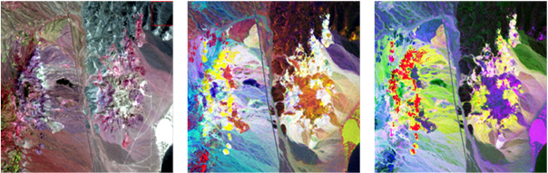 |
-
2025-02-28
Technology
ADG has developed the Hymi-Xin…
-
2025-02-28
Data
Chinese Satellite Hyperspectra…